
Opening Settings
Press S to open the Settings dialog. Settings are saved to config.yaml when you click Save. The app looks for this file in the same folder as the executable when you run the packaged app, or in the project directory or your user folder (~/.dxchrono/config.yaml) when run from source; the first location where a config is found is used, and Save writes to that file. You can override the config file with -c path/to/config.yaml (see Command line options).
Text fields (station details, integration hosts, DX Cluster profile editor, watchlist input, and similar): click to place the cursor; use the arrow keys, Home, End, Backspace, and Delete while editing. Ctrl+A selects all text in the active field; your next keystroke replaces the selection. Right-click pastes where supported (e.g. API keys).
Config file locations (quick reference)
| Run mode | Config lookup / save behaviour |
|---|---|
| Packaged executable | Looks for config.yaml next to the executable; Save writes there. |
| Run from source | Looks in project config.yaml, then ~/.dxchrono/config.yaml; Save writes to the file that was found. |
| Command line override | -c / --config PATH forces that file to be used and updated. |
Settings tabs
If your screen is narrow (or lots of features are enabled), tab names may not all fit at once. Use the tab-strip arrows, or spin the mouse wheel over the tab row, to slide left/right and reach hidden tabs.
Station
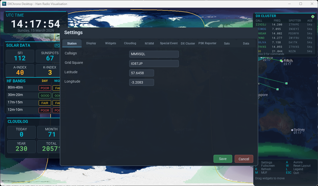
Your station identity and location:
- Callsign – Your amateur radio callsign (used for PSK Reporter and display).
- Grid square – Maidenhead locator (e.g. IO91wm). The app converts this to latitude/longitude.
- Latitude / Longitude – Your QTH in degrees. Used for the map marker, grey line, and distance calculations.
License
If you bought a copy of DXChrono, store your License key from your order email. The app talks to the license service for you—you do not enter a server address. Use Activate to register this PC (your license usually allows up to five computers per key; the service keeps count). Use Validate to check the key again without using an extra slot. Validate license when app starts runs a quick background check when a key is saved. If you have lost the key, use Lost your key? to open the recovery page (enter the purchase email; keys are resent by email). The first time you run the app without a key, a separate license window appears before the map; more detail is in Integrations → License.
Display
Frame rate (FPS) is set on this tab with fullscreen and map options; the Performance tab is only for how the world picture loads (memory and startup), not for FPS. Options are in two columns: View (window, map mode, grid) and Overlays (cities, QTH, aurora, tropo, SpE, sun/moon).
- Fullscreen – Start in fullscreen or windowed mode.
- FPS – Frame rate (default 30).
- Map mode – Choose the standard flat world map or the interactive 3D globe view.
- Map east/west centre – Set the longitude at the centre of the map (for example, around −90 to centre North America).
- Map overlays – Grid, gridsquares, CQ/ITU zones, cities, QTH marker, aurora, tropo, SpE (beta), and sun/moon.
- 3D globe controls – In globe mode, drag or arrow keys rotate the globe; mouse wheel still zooms.
- MUF overlay – Controlled from the keyboard (M) rather than a Settings checkbox.
- Tropo overlay – Current 3-hour F5LEN tropospheric forecast on the map. Press T or enable Show Tropo Overlay under Display. Turning tropo on turns aurora off (one heavy overlay at a time), and the other way around. Thanks to Pascal Grandjean, F5LEN, for permission to use this data.
- SpE overlay (Beta) – Live sporadic-E openings as colour washes on the map: 10 m cyan, 6 m green, 4 m yellow, 2 m orange. A colour key shows which is which. Press E or enable Show SpE Overlay (Beta). It can sit with tropo or aurora. Set your SpE server address on the SpE (Beta) tab. Optional F-hop (purple) is a long-path hint only — it cannot tell Es from F2.
- Propagation line width – − / + buttons (1–4) thicken great-circle lines on the 2D map and globe; 1 is the default minimum. See Map & Widgets for how lines behave on the map.
Map 3D
Shown when you need globe-only options: label density, arc style for great-circle lines, atmosphere glow, and optional auto spin with speed and spin redraw rate (10 / 15 / 20 FPS). While auto-spin is on, heavy overlays and great-circle lines pause so the globe can keep turning smoothly (especially on a Raspberry Pi); they come back when spin stops. These apply when Map mode on the Display tab is set to the 3D globe.
Performance
The tab shows a short note at the top: options here apply after Save and reload the map — there is no live preview while Settings is open. A machine preset (Custom, Raspberry Pi, 4 GB PC, Desktop) fills the other options on this tab plus display frame rate, 3D globe texture width, satellite overlay interval, auto-spin redraw rate, and the logbook map-line cap. They control how large world images are loaded for the 2D map and 3D globe (memory use and startup time):
- Base map size – the unzoomed 2D world picture: 720p (1280×640), 1080p (2160×1080), 4K (3840×1920), or Auto (follows the window width). Raspberry Pi preset uses 720p; 4 GB PC uses 1080p. On a 1920×1080 window those three are close in RAM (about 190 / 195 / 210 MB). The full NASA 21600 picture is not used at startup — it loads only after you zoom the flat map in (about 980 MB once loaded; the first zoom can briefly peak near 2.5 GB), and not on the low-RAM path.
- Map memory mode – Auto uses the lighter load path when installed RAM is at or below the cutoff (about 4 GB unless you change it). Low-RAM path forces that behaviour. Full detail allows the NASA zoom layer when you zoom in.
- Low-RAM cutoff (MiB) –
0keeps the built-in default (4096). Raised or lowered only affects Auto. - 2D zoom layer cap and Decode cap –
0means built-in defaults. Non-zero values set upper limits on how many picture elements are processed while loading (advanced). - Map resize quality – trades speed against sharpness when shrinking the world image; Best is slowest on a Raspberry Pi.
- 3D globe texture width – how detailed the world picture is on the globe (default 2048). Lower values start faster on a Raspberry Pi.
- Logbook map line cap – limit how many Cloudlog, ADIF, QRZ, and N1MM lines are drawn together (default 80;
0draws all). Newest contacts keep their lines first. If several logbooks have lines on, a short note appears in Settings.
Click Save to apply (the map reloads). For environment-variable equivalents and edge cases, see Troubleshooting → Slow startup or heavy map load.
Widgets
Show or hide on-screen panels in two columns: Display (clock, solar, HF/VHF bands, SpE heatmap, sun/moon, station, help) and Feeds & lists (Cloudlog, ADIF, PSK Reporter, Reverse Beacon, satellite passes, contest calendar, WeatherLink, Weather Underground). DX Cluster and N1MM widgets are controlled from their own tabs when enabled. You can drag widgets to reposition them; positions are saved.
K-index 48h sparkline is off by default. When on, the Solar Data panel grows a thin strip of planetary K (Kp) for the last 48 hours, so you can see whether a geomagnetic storm has already passed. It uses the NOAA K product; the rest of the Solar numbers stay as they are. See Map & Widgets.
VHF conditions is off by default. When on, the panel shows aurora and E-skip from the same feed as HF bands. VHF Region (All / Europe / North America) hides the other continent’s E-skip; you can also tap All / EU / NA on the panel itself. See Map & Widgets.
SpE heatmap (Beta) is off by default. When on, the panel lets you choose 10 m / 6 m / 4 m / 2 m and optional F-hop, and turn the map overlay on with Map. The server address lives on Settings → SpE (Beta). See Map & Widgets → SpE heatmap.
Sun/Moon Az-El panel: Shows azimuth and elevation for the Sun and Moon at your station. It uses Station latitude/longitude, or the centre of your grid square if those are not set.
Data
How often data is updated (in seconds): solar data, band conditions, aurora data, tropo overlay, grey line, Cloudlog, ADIF Logbook, QRZ Logbook, WeatherLink, and Weather Underground (default 120 s when enabled). Increase intervals to reduce network and CPU use. Tropo defaults to 900 seconds (15 minutes) and also checks shortly after :15 each UTC hour for a newly published forecast.
Note: panels refresh independently, so values can update at different times.
Software updates
DXChrono can quietly check whether a newer build is available. It does not install updates for you; it only reads a small text file on the internet and compares the version number to the one you are running. Your callsign, logbook, or license details are not sent as part of this check.
- Check for app updates – Turn this off if you prefer the app never to look for newer versions (for example on a PC with no internet, or a strict club network).
- Update check frequency – Daily means at most one check per calendar day (UTC). Every startup checks each time you launch DXChrono.
- Check for Updates (button at the bottom of this tab) – Runs a check straight away. A short message appears at the bottom of the Settings window when the check finishes: if you are already on the latest version, you will see a green confirmation; if the check could not complete (no internet, blocked site, etc.), you will see a short warning. If a newer version is available, an Update Available window opens on top of Settings with two links: Download (installer page) and View Changelog (what changed). Use Later to close the window and carry on.
If an update is found while Settings is closed, the same Update Available window appears when the main map is showing, as soon as the app is not busy with another dialog.
For download files and release notes, see desktop.dxchrono.com/download and desktop.dxchrono.com/changelog. More help if checks fail: Troubleshooting → Update checks.
Contest Calendar
Contest Calendar now has its own tab. Polling runs when the Contest Calendar widget is enabled (Widgets tab). Use the Contest Calendar tab to set RSS refresh interval, lookahead days, optional custom feed URL (default https://www.contestcalendar.com/calendar.rss), and widget font sizes.
Contest widget fonts: use Contest widget font (px) for main row text and Contest widget meta font (px) for secondary time/status lines.
Watch
Use the Watch tab to track specific callsigns (and SOTA/POTA references you add) from DX Cluster, PSK Reporter, Reverse Beacon, SOTA, and POTA.
- Enable watch list matching – Master on/off switch. When off, no watch matches are collected.
- Show Watch List panel – Enables the Watch List widget area. The panel auto-hides when there are no current matches, and reappears when a match arrives.
- Match timeout (sec) – How long a match stays in the watch list before it is considered old and dropped.
- Match history size – Maximum number of stored matches kept in memory/widget list.
- Widget list font (px) – Text size for watch rows in the Watch List widget (larger text = fewer visible rows).
- Show alert cards for new matches – When a watched callsign appears, a short card in the top-right shows the feed and frequency. Cards clear automatically after the display time below.
- Play alert sound (ding) – Optional short sound with each new alert (still respects the per-callsign cooldown).
- Alert cooldown per callsign (sec) – Minimum gap between alerts for the same callsign so busy bands do not spam the screen (default 300).
- Alert card display time (sec) – How long each alert card stays visible before it fades (default 120).
Press N at any time to mute or unmute alert sounds and cards without opening Settings — see Controls.
Callsign editor: type a callsign in the input box and click Add. Click an existing row to load it for editing, then click Update. Use Delete to remove the selected row or Clear to remove all watched callsigns.
What is matched: DX Cluster matches the DX callsign; PSK Reporter matches the other station; Reverse Beacon matches the skimmer that heard you. For SOTA and POTA you can also watch activator callsigns or summit/park references (for example G/LD-003 or GB-0042). See Integrations → SOTA and POTA.
Reverse Beacon, SOTA, and POTA
Those feeds have their own Settings tabs (host options, map markers, continent filters, and so on). Full setup is under Integrations → Reverse Beacon, SOTA, and POTA. Enable the matching panels under Widgets when you want them on screen.
Cloudlog
Connect to your Cloudlog instance for QSO stats and recent contacts. Enter base URL, API key, and optional public slug. Use Test to verify. Enable the Cloudlog widget in the Widgets tab.
Map QSOs (days) limits how old a Cloudlog contact can be and still appear as a map marker or line (default 2 UTC days: today and yesterday). Raise it if you want a longer trail of pins; set 1 for today only. The Cloudlog stats panel is not affected.
WeatherLink
Optional Davis WeatherLink current-conditions panel. Enter your WeatherLink v2 API Key and API Secret (from weatherlink.com/account), optionally a station UUID, then pick temperature, wind, pressure, and rain units separately (for example °C with mph and mb). Use Test to list stations. Enabling WeatherLink turns the panel on (same as Cloudlog). Poll interval is under Data → WeatherLink (sec). Full steps: Integrations → WeatherLink.
Weather Underground (WU)
Optional Weather Underground personal weather station panel (separate from WeatherLink). Enter your API Key and case-sensitive Station ID (from wunderground.com), then pick temperature, wind, pressure, and rain units. Use Test to confirm the latest observation. Enabling Weather Underground turns the WU panel on. Poll interval is under Data → Weather Underground (sec). Full steps: Integrations → Weather Underground.
ADIF Logbook (file)
Use a local ADIF file as a live QSO source when you do not use Cloudlog or QRZ. Enable the ADIF tab, set your .adi path (or click Browse), and DXChrono will monitor the file for recent QSOs to drive map markers and the dedicated ADIF Logbook panel. You can choose map labels/lines and how many recent QSOs to keep. Set refresh under Data → ADIF Logbook (sec).
QRZ Logbook
The QRZ (logbook & XML) tab is split into two columns: Logbook on the left (API key, map options, FETCH limits) and XML lookup on the right (login and per-feed toggles).
Optional QRZ Logbook API integration: enter your logbook access key (you can right-click the field to paste from the clipboard), enable the feature, and recent QSOs appear on the map as square markers (Cloudlog uses diamonds). There is no separate stats widget for QRZ—only map markers, optional labels and great-circle lines, and tooltips. For a pin on the map, each QSO needs a gridsquare or latitude/longitude in the ADIF QRZ returns; widen FETCH date span or FETCH max records if you expect more contacts in the window.
Fetches use FETCH with BETWEEN:start+end and MAX: in one OPTION string (comma-separated, no spaces, per QRZ). Default FETCH date span is 7 inclusive calendar days through today (adjustable on this tab). Use Test (STATUS) to confirm your key; live FETCH needs a QRZ subscription that includes Logbook API access. Set refresh under Data → QRZ Logbook (sec). The HTTP User-Agent is DXChrono.
FETCH debug (terminal) — When this checkbox is on (or when environment variable DXCHRONO_QRZ_DEBUG_ADIF is 1), each FETCH logs non-secret response fields and the first part of the ADIF to the terminal you launched the app from. The API key is never printed. Use for short troubleshooting sessions if markers or parsing look wrong.
QRZ XML (map lookups)
Separate from the Logbook API: your QRZ.com login (XML data service) can fill map positions when the built-in prefix table has no coordinates, and can refine a plot when QRZ returns a Maidenhead grid (then the map uses that locator instead of the prefix-table position). Enter XML username and XML password on the same tab, then enable Lookup: DX Cluster, Lookup: Reverse Beacon, and/or Lookup: N1MM+ QSOs. If QRZ is slow or unreachable, DXChrono keeps the prefix-table or N1MM grid result. Use XML in the footer to check login (your password is not printed). Lookups are cached to limit repeat requests; the app also re-logs in on a timer so long uptimes do not keep a stale session key. Optional environment variables: DXCHRONO_QRZ_XML_TIMEOUT (lookup timeout, seconds, default 12), DXCHRONO_QRZ_XML_REFINE_TIMEOUT (shorter cap when CTY already had coordinates, default about 4s or a third of the main timeout), DXCHRONO_QRZ_XML_SESSION_MAX_SEC (re-login after this many seconds with an open session, default 72000).
DX Cluster
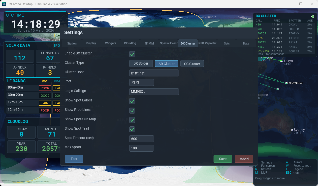
Telnet DX cluster connection using profiles: each profile has a name, host, port, login callsign, and cluster type (DX Spider, AR Cluster, or CC Cluster). Mark one profile as primary. DXChrono connects to the primary first; if that fails, it tries your other profiles in list order, then tries the primary again on the next reconnect.
To add another profile, click New profile, enter the details in the form, then Add. To change an existing row, select it in the list, edit the fields, and click Update. Delete removes the selected profile; Set primary chooses which node is tried first. Select a profile and use footer Test to check that endpoint before you Save.
Display options (two columns at the top of the tab) cover spot labels, great-circle propagation lines, map spots, spot trail, timeout, max spots, and DX Cluster widget font size. Spots from skimmer-style spotters on the cluster feed (e.g. W3LPL-#) are shown like any other DX spot. The DX Cluster panel shows connect and failover status when spots have not arrived yet. See Integrations → DX Cluster and Map & Widgets → DX Cluster.
PSK Reporter
MQTT connection to PSK Reporter: host, port, TLS. Choose “who's hearing me” and/or “who I'm receiving”. Configure labels, great-circle propagation lines, spot trail, timeout, and max spots. Your station callsign is used to filter spots. The tab also includes a Test button.
The on-screen PSK Reporter widget (enable it under Widgets) lists recent spots in a table with call, frequency, mode, an SNR bar (visual only), and age. List mode and band filters follow the options on this tab. See Map & Widgets → PSK Reporter for how to read the SNR column (including what the bar colours mean), wheel scrolling, and narrow layouts.
SpE (Beta)
This tab is marked Beta. Point Desktop at your SpE server (the address of a spe-ingest service that paints openings from PSK Reporter midpoints on 10 m, 6 m, 4 m, and 2 m). Enter the Heatmap URL as the host only (no extra path). Poll interval is how often the overlay refreshes while it or the SpE panel is on (default 2 seconds). Tick which bands to show, and optionally F-hop / long-path (purple; diagnostic only). Your server must subscribe to 4 m spots if you want the yellow layer. Turn the map overlay on under Display or with E. See Integrations → SpE heatmap.
HF Band Conditions
Live DXChrono HF conditions for the Solar and HF Band panels (real spot activity plus solar indices — not a HamQSL forecast paste). On by default. Use this tab to turn it off, set Poll interval (default about 4 minutes), or choose Score activity from (Worldwide / My grid / Continent / DXCC), then Save. Extra fields appear only for the mode you pick. The HF Band panel footer shows DXChrono HF when the live feed is active. Press R if the panel has not updated yet. When this feed is off, Solar/Band use the longer intervals under Settings → Data.
- Worldwide — all paths
- My grid — Station grid (or optional Grid square) for day/night and continent
- Continent — activity whose path midpoint sits on that continent
- DXCC — transmitters in that entity (e.g.
GMorScotland)
The VHF Conditions panel still uses the classic solar feed even when live HF is on. If the live HF service is down, Desktop falls back to dxchrono.com / HamQSL automatically. When a day or night column has no spots yet (for example Europe’s night row in the afternoon), the label follows a solar estimate instead of showing Poor — so empty “later tonight” rows do not put you off. A thin trickle of spots is enough to leave that estimate and score from activity, so one low band can look Good (estimate) while the next looks Poor; paired rows such as 80–40 m use the worse of the two.
Satellites (Sats)
Enable satellite tracking and toggle labels/footprints on the map. Select which satellites to track from the list and set the minimum footprint elevation. Upcoming Passes options are also here: UTC/local pass times, lookahead hours, and pass-list font size. Press Y to show/hide the overlay. While satellites are on, Desktop refreshes the TLE file about every six hours if the internet is available, so a kiosk left running does not need a restart for ISS and other sats to stay accurate.
N1MM
Listen for N1MM Logger+ UDP broadcasts: enable, set UDP port (default 12060), listen address 0.0.0.0 on a Pi or remote display, and map line colour mode. Enable N1MM status/recent-QSO widgets in the N1MM tab; set QSO list font size for the recent-QSO table. Drag the N1MM QSO list panel by its title bar; resize from the bottom-left grip (like DX Cluster). In N1MM Broadcast Data, enable Contacts (and Radio if needed) on port 12060. On the logging PC use 127.0.0.1:12060 for local apps; add subnet broadcast (e.g. 192.168.1.255:12060) so a Pi on the LAN receives packets — see Integrations → N1MM+ UDP.
Special Event
For event stations and open days: enable mode, choose data source (Cloudlog or N1MM+), event name, dates, tagline. Options for last-worked banner, contacts today, distance to last QSO, map legend, and banner scroll speed. See the dedicated Special Event Station Mode page.